
Big news! See how that second city in the title doesn’t have a “WA” after it? I finally crossed a state line! Definitely the news of the day. But let’s back up a bit and do the final run-down of my adventures in Washington State.
I once again had trouble getting going at an early hour. This time I set my alarm early enough, I just couldn’t get everything together. Among other things, I was so exhausted last night that I hadn’t packed, so that needed to be done this morning. By the time I dragged myself downstairs it was 6:30, which was when the hotel started serving its free breakfast. Knowing there was only one town on the way today, and that it was halfway to my destination, I decided to grab some of that free breakfast and wound up finally hitting the road shortly before 7.
It turns out that today I could get away with such a late start. It stayed cool and cloudy all morning. Even with the weather in my favor, there was still adventure to be had. The ride started with a few miles of moderate climb, followed by 3 miles of 6%(!!!) downgrade. While I’d had a few short descents in Yakima River Canyon, this was my first prolonged steep descent. Turns out if you put all the weight on your bike in the back, you don’t have to worry about going over the handlebars, but you do have to worry about getting blown to the side. With every sudden cross breeze or back draft from an oncoming truck, I really felt like I was at risk of toppling. So I wound up clinging to the brakes and keeping my speed in the 25-30 range. It’s funny, because if I were riding unencumbered I would have had no issues going 40 or more and enjoying every second of it. But such is the price for how I rigged my setup.
About 14 miles in, the terrain more or less leveled out. At that point, it became more a matter of wind, which was very variable. At one point I had a tailwind so strong I was going uphill at 19mph and still felt the wind at my back. At another point the wind shifted, even though I was biking in the same direction, and suddenly I was struggling to maintain 10mph. At about 23 miles I arrived at the town of Dodge. It consisted of a highway junction and a public restroom. And some windmills.

In fairness, it was a fairly popular restroom. While I was standing around stretching and drinking some water, two cars pulled up for their occupants to use it.
After I got the heck out of Dodge (ok, I was just looking for an excuse to say that), it was only another 12 miles or so to Pomeroy. About 5 miles out of Pomeroy, the wind became consistently in my favor and I was basically propelled uphill into town. I can only hope that I can have conditions like this— cloudy, 60s, and a tailwind— when I cross the Great Plains. If so, I’ll be across them in no time!
It was not quite 9:30 when I rolled into Pomeroy, and I was already halfway done with my distance for the day. To give some background, Pomeroy is the seat of Garfield County, the smallest county in Washington State. The city has 1400 people, and the entire rest of the county only has 900. (Thus towns like Dodge, which are apparently built around a public restroom.) Pomeroy does maintain its wild west image as a way to draw tourists, but on a Tuesday morning it’s pretty sleepy, even in the summer. I couldn’t even go to the county museum because it didn’t open until 1. The architecture is still cool though.


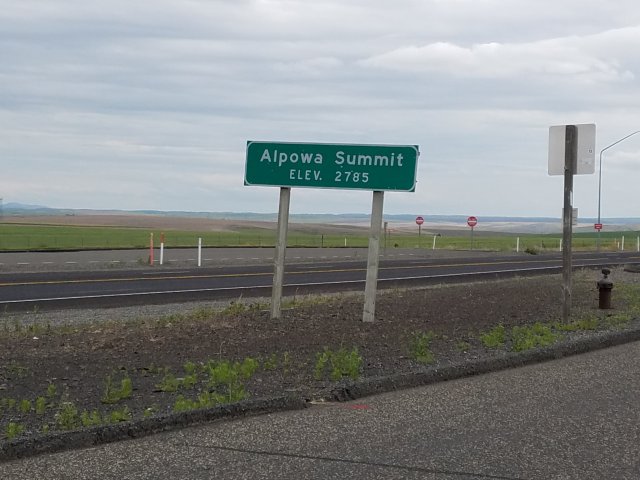
Since it was still so early in the day, I spent a very leisurely time walking around town and getting a bite to eat, so it was 11 by the time I left. Coming out of Pomeroy, the road climbs 900 feet in 9 miles. Fortunately, the tailwind that had propelled me into town continued to propel me out of town, and only the last couple of miles even felt like a real climb. Eventually I reached Alpowa Summit, the highest point on my ride so far.
Again there was a historical marker about the Lewis & Clark expedition. Those men must have been some pretty serious sweet talkers to get the local Indians to show them this route between the Snake River and the Blue Mountains. (And am I the only one who thinks of Tolkien’s Blue Mountains in Eriador when I hear that name?)
The first 5 miles of descent from the pass were nothing short of terrifying. Compared to my earlier descent, this one was steeper, on a worse surface, and with more bends. My legs may have gotten a rest, but my hands got a serious workout using the brakes to keep my speed to 20-25.
After 5 miles the descent continued at a more gradual pace. Now to back up a step, I had noticed leaving Dayton that the mileposts on US-12 were in the high 300s. It didn’t take complicated arithmetic to figure out that I was going to pass milepost 420 on the descent. This is relevant because when Colorado legalized recreational marijuana, it was in the news that milepost 420 on I-70 kept being stolen and eventually the state had to replace it with milepost 419.99. Since Washington legalized recreational marijuana at the same time as Colorado, I wondered if they had had the same problem. Turns out they did, but they came up with a different solution.

No one’s going to steal a mile marker when it’s on a concrete post!
After mile 420, the wind became more variable and sometimes I had to pedal into a headwind despite going downhill. Eventually though I reached the Snake River Valley, which has some nice scenery.

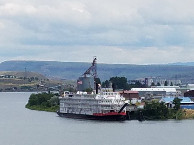
And in a few more miles I was in Clarkston, which apparently has some riverboats like the Mississippi.
So the interesting thing about the rest of the day is that for the first time I used the warmshowers website, which is basically couch surfing for cyclists, to find a host. I matched with this incredibly nice couple named Jim and Christy, who host a number of cyclists who pass through Lewiston over the course of the year. Christy also did a cross-country ride herself a few years ago, so she was able to give me some pointers.
In any case, the rest of the day was super chill. I went by Jim’s work in Clarkston and he gave me directions to their house in Lewiston. After a shower and a nap, I joined them for a nice pizza dinner. Turns out they’re wine enthusiasts, so we managed to kill two bottles of local Idaho red wine. Now, you’re probably a bit perplexed since Idaho is known a lot more for its potatoes than for its wine, but Pacific Northwest viticulture doesn’t stop at state lines, so this region of Idaho along the Washington border actually has some very good and underrated wineries.
To top off the evening, Jim and Christy were asking me what I do for work. Since I had a bit of wine in me, besides mentioning my day job I also mentioned that I’m a High Holiday cantor. Since they had a bit of wine in them, they asked me to sing a bit of the High Holiday liturgy. Since they were my hosts and had not only given me free lodging but also dinner and wine, I couldn’t say no, so I sang the first paragraph of the Unetaneh Tokef in their living room. Sometimes you can’t make this stuff up!
That’s all for tonight! I’m not sure how long it will be before my next update. I’ll be spending the next two nights in Nez Perce-Clearwater National Forest as I climb up to Lolo Pass, on the Idaho-Montana border. I’m sure I won’t have phone reception, so it will be entirely a matter of whether my motels have wifi. See you perhaps tomorrow or Thursday in the forest, or perhaps Friday in Missoula!
Total distance: 71.5 miles
Average speed: 15.0 mph
