Happy Fourth of July!
243 years ago, some guys gathered in Philadelphia to proclaim independence from Britain… so that I could have a massive country to bicycle across 🙂
But seriously, I hope you all had a good Fourth and celebrated while being aware of both our country’s incredible accomplishments and its incredible shortcomings.
And now back to biking. The motel I was staying at didn’t start serving breakfast until 7, so I figured I could set my alarm for 6:30. Of course, it took a while to drag myself out of bed and get dressed, so by the time I got to breakfast it was 7:30. Then I still had to pack, so I didn’t hit the road until 8:30. Fortunately, I only had 65 miles planned for today.
Now, some background about the geography here. Lowell is located at the confluence of the Lochsa and Selway Rivers, where they form the Middle Fork of the Clearwater River. Above Lowell, US-12 follows the Lochsa up into the Bitterroot Mountains. If you’ve never heard of the Bitterroot Mountains, you’re not alone; I hadn’t either before this trip. But if you look on a map that marks state borders and the Great Divide it’s easy to see. In southern Montana, the border with Idaho follows the Great Divide. However as you go farther north, the Great Divide cuts up through Montana. The Montana-Idaho border instead follows the Bitterroot Mountains, which are an offshoot of the Rockies which cut northwest. Short of it is, I have to cross the Bitterroot Mountains to get into Montana, and then once in Montana I’ll have to cross the main section of the Rockies to get over the Great Divide. Even shorter of it is, I had to climb 2000′ on net today.
One nice thing about today’s ride is that due to the holiday there were almost no trucks. It made for a lot more comfortable biking, even though there were still plenty of cars and motorcycles passing me. For the most part there was a nice tailwind too. Also, the scenery along the Lochsa River was really beautiful. Not too far out of Lowell it looked like this:

A few miles farther up, I caught a view of a creek joining the river from the other side.

Now, while I was in Kooskia yesterday, I happened to chat with a Forest Service Ranger. He said it was too bad I wouldn’t be able to do much hiking in the forest since I’d be focused on biking, but he strongly recommended hiking to Snowshoe Falls, since it’s less than a mile round-trip from the road. If you’re in the area and want to hike it, the trailhead is quite tricky to find. About half a mile past milepost 117, there’s a historical marker on the river side of the road. If you cross the road from the marker, you’ll find a tiny sign directing you to Snowshoe Falls. I’d say the falls are worth seeing.
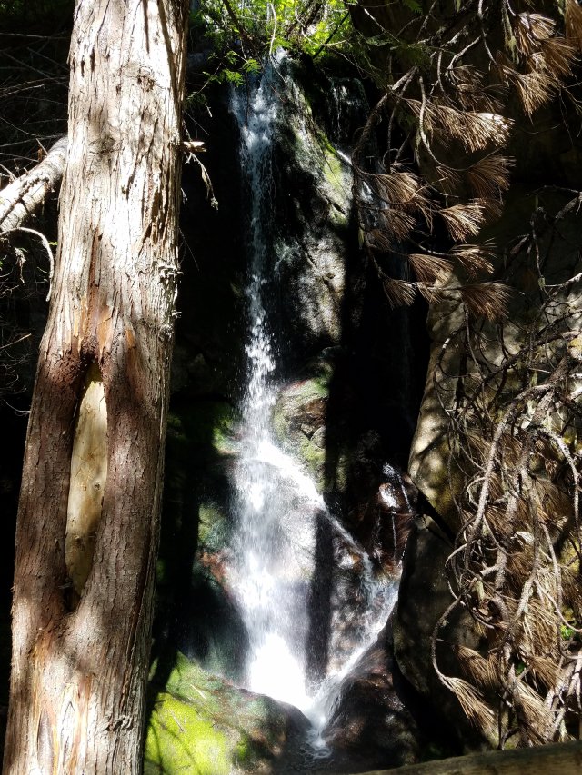
There were also some really nice flowers blooming along the trail to the falls.

25 miles out of Lowell was a really important stop. In the 65-mile stretch from Lowell to Powell (which don’t rhyme, no matter how similar they look), there is exactly one place to get potable water, and that is a campground 25 miles past Lowell. So I turned off the road to refill my water, which would have to last me the next 40 miles. The campground also had a nice big pavilion where I was able to rest a bit in the shade and have some food. The bridge over the river leading to the campground also had a nice view.

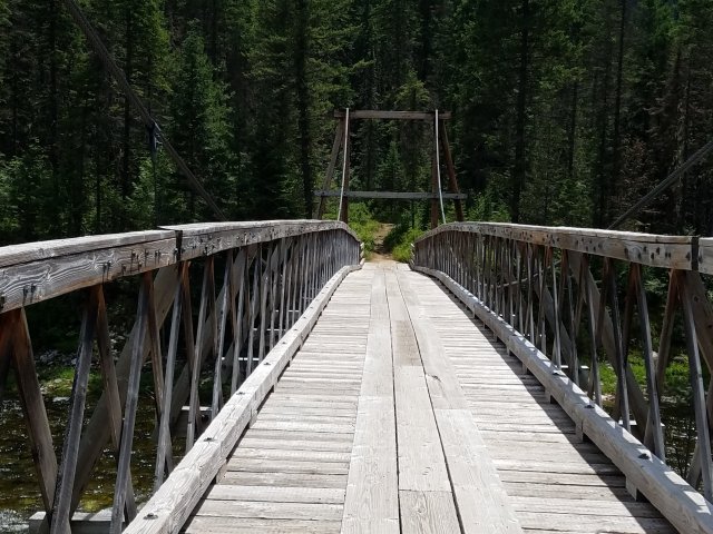
Of course, by the time I finished at the campground it was past 11, which means it was once again the heat of the day. So from there on, my day gets a lot more boring. I basically decided to take a rest every 10 miles and get through the day that way. It left me a bit too exhausted to take many more photos. However, at my 20-mile rest stop (i.e., 45 miles out of Lowell and 20 miles to Powell) I stopped by this hiking bridge across the river, which was pretty cool.
Eventually I rolled into Powell at 3:30, and that’s a wrap! I’m staying in a cabin without running water, but they do have Wi-Fi and communal shower facilities. Also, my neighbors in the cabin next to mine are really friendly and, being from Oregon, brought a ton of Oregon beer and wine which they are happily sharing with me. It’s a nice way to celebrate the Fourth.
Tomorrow I’ll finish my climb in the first 13 miles and then descend into Missoula where I’ll have an off day. Should be a good way to unwind after all this climbing.
Total distance: 65.6 miles
Average speed: 14.0 mph

But imagine if the founding fathers hadn’t declared independence… you could extend your bike ride through the British Empire’s colonies all around the world!!! (I’m sure the Ben in that alternate universe is doing just that, anticipating a ride extension from Boston up to Newfoundland, flying to Ireland, circling it then ferrying to Scotland, riding down to London, and resting there a few says before your trip to India and Australia.)
Seriously, these are great posts! I’m really enjoying being able to follow you and see the highlights of your trip (and also enjoying not having to do the pedaling myself). Keep it up, and bike safely!
Happy 4th!
LikeLiked by 1 person